Flights and Nearest Airports to Ingapirca
There is no airport in the Cañar province, and no commercial airstrip serves the Ingapirca municipality directly. Travelers searching for flights to Ingapirca must fly into one of two regional airports and complete the journey by road. The two viable gateways are Mariscal Lamar Airport (CUE) in Cuenca and José Joaquín de Olmedo International Airport (GYE) in Guayaquil. Choosing between them depends on your origin city, budget, and tolerance for ground transit at altitude.
Cuenca Airport (CUE) — The Closest Option
Mariscal Lamar Airport sits roughly 80 kilometers (50 miles) south of the ruins, making it the nearest commercial airfield. Domestic carriers operate daily flights from both Quito and Guayaquil into Cuenca. The Quito-to-Cuenca flight takes approximately 50 minutes, a dramatic improvement over the 8 to 9-hour overland bus alternative from Terminal Terrestre Quitumbe. One-way fares typically range from $35 to $75 USD depending on how far in advance you book and the season. From Guayaquil, the flight is even shorter—about 45 minutes—and usually costs $30 to $60 USD one way. Upon landing at CUE, a taxi to the Terminal Terrestre de Cuenca takes 10 minutes ($3–$5 USD), where you can connect to the direct or indirect bus routes detailed below.
Guayaquil Airport (GYE) — The International Hub
Most international arrivals land at GYE, which receives far more long-haul routes than Cuenca. If your itinerary does not include a domestic connection to CUE, you face a 4 to 5.5-hour ground transfer from Guayaquil to the Cañar province (detailed in the driving routes section below). For travelers with limited time, booking the 45-minute domestic hop from GYE to CUE is strongly recommended over the long bus climb into the western cordillera. The altitude shift from sea-level Guayaquil to 3,160 meters at the ruins is severe; flying to Cuenca (2,560 meters) provides an intermediate acclimatization stop before the final ascent.
Quito Airport (UIO) — The Northern Alternative
Mariscal Sucre International Airport in Quito serves as Ecuador’s primary high-altitude hub. While Quito is geographically distant from Ingapirca—roughly 260 kilometers (162 miles) to the north—it offers the widest selection of international arrivals. The practical choice from Quito is a domestic flight to Cuenca (50 minutes, $35–$75 USD) followed by ground transport, rather than the grueling 8 to 9-hour bus ride via the E35 Panamericana. If you must drive from Quito, expect 5 to 6 hours of winding mountain highway with limited fuel stops between Riobamba and Azogues.
Regardless of which airport you choose, the final leg to Ingapirca is always by road. Review the bus schedules, driving routes, and tour options in the sections below to plan your ground connection efficiently.
Understanding the Journey to the Cañar Province
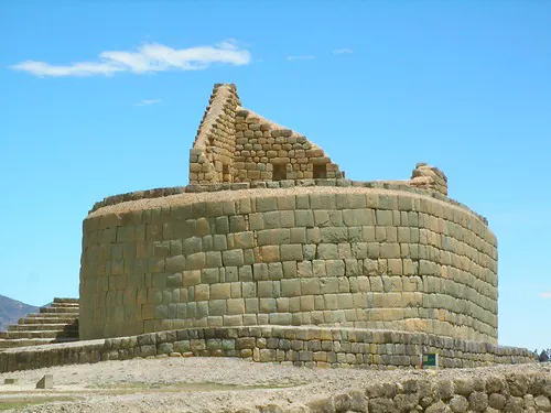
Reaching the most significant archaeological complex in Ecuador requires navigating the specific logistical landscape of the high Andes. The site sits at an elevation of 3,160 meters (10,367 feet) in the Cañar province, isolated from major international transit hubs but accessible through a well-established network of regional highways and mountain roads. Travelers must prepare for dramatic altitude changes, winding routes, and distinct microclimates during transit. Understanding the available transportation infrastructure is essential for establishing a realistic itinerary, whether utilizing public bus networks, securing a private rental vehicle, or arranging a specialized transfer.
Before initiating any travel plans to the region, visitors must address the mandatory 2026 entry protocols established by the Instituto Nacional de Patrimonio Cultural (INPC). To control daily capacity and protect the structural integrity of the stone foundations, the INPC now strictly requires all visitors to secure online reservations at least 24 hours in advance via their official portal. Walk-up ticket sales at the gate are highly restricted and frequently unavailable during peak transit days. Current INPC schedules limit operating hours to Wednesday through Sunday, from 09:00 AM to 4:15 PM, extending slightly to 4:30 PM on official national holidays. The site is entirely closed on January 1st and December 25th. Visitors can find an exhaustive breakdown of these entry requirements, pricing exemptions, and capacity rules on our dedicated Tickets & Tours page.
Because the complex is situated at a high elevation, the transit process itself serves as a crucial period for acclimatization. The gradual ascent from coastal plains or lower inter-Andean valleys requires physical adjustment. Travelers prone to altitude sickness should consult our comprehensive guide on How to Avoid Altitude Sickness in the Andes before selecting a rapid transit option from sea level.
Cuenca as the Primary Southern Gateway
The city of Cuenca operates as the most practical staging ground for the final leg of the journey. Located in the adjacent Azuay province, Cuenca offers a highly developed tourism infrastructure, superior road connectivity, and immediate proximity to the Cañar border. While northern hubs like Quito are geographically distant—requiring an exhausting 8 to 9-hour long-haul bus ride from Terminal Terrestre Quitumbe to Cañar (using providers like Express Sucre for $10 to $17)—Cuenca allows for a streamlined, single-day excursion.
Independent travelers renting a vehicle in Cuenca will find the drive north takes approximately 1 hour and 15 minutes to 1.5 hours, covering a distance of roughly 65 kilometers. The most efficient route utilizes the Panamericana Highway E35 (also known as the Troncal de la Sierra). Drivers will remain on the E35 until reaching the designated right turn onto the San Pedro Road, which leads directly to the archaeological boundary. The highway is generally well-maintained, though drivers must exercise caution regarding heavy commercial truck traffic and sudden fog banks common to the Andean highlands. For those planning an extended stay in the Azuay staging area, reviewing our guide to Exploring Ecuador: Nearby Attractions provides valuable context on regional highlights.
For visitors opting out of independent driving, Cuenca supports an extensive network of specialized transit providers. Many travelers choose to book a private tour from Cuenca to Ingapirca with lunch, which removes the friction of navigating multi-leg public transit. It is crucial to note that most organized shuttle tours departing from Cuenca enforce strict age parameters—typically a minimum of 5 years and a maximum of 65 years. This policy exists due to the physical demands of walking the uneven, high-altitude terrain at the ruins. Families traveling with individuals outside this bracket should secure private transport to ensure a customized pace.
Cuenca’s proximity and well-maintained highway network make it the undisputed logistical hub for accessing the Cañar province. Avoid the exhausting cross-country bus routes from Quito if your primary objective is the archaeological complex.
Bus Schedules and Transit Times to Ingapirca
Public transportation from Cuenca provides an economical and reliable method for reaching the complex, provided travelers understand the specific schedules and transfer points. There is a distinct difference between the single direct bus route and the multi-leg indirect option. Below is the hyper-specific transit data for the 2026 season.
| Departure Point | Transport Type / Provider | Schedule / Frequency | Duration | Estimated Cost (USD) |
|---|---|---|---|---|
| Cuenca (Terminal Terrestre) | Direct Bus (Cooperativa Cañar) | Strictly 9:00 AM (Occasional 12:30 PM) | 2.5 Hours | $3.50 – $4.00 |
| Ingapirca (Return to Cuenca) | Direct Bus (Cooperativa Cañar) | 1:00 PM or 1:30 PM and 3:45 PM | 2.5 Hours | $3.50 – $4.00 |
| Cuenca to Cañar Town | Indirect Bus (Express Sucre / Coop Cañar) | Departures every 20-30 minutes | 2 Hours | $2.50 – $3.00 |
| Cañar Town to El Tambo | Local Transit (Blue and White Bus) | Continuous / High Frequency | 15 Minutes | $0.50 |
| El Tambo to Ruins | Continuing Local Bus | Continuous / High Frequency | 25 – 30 Minutes | $0.75 |
| El Tambo to Ruins | Direct Taxi Transfer | On Demand at El Tambo Plaza | 10 Minutes | $7.00 – $9.00 |
The direct route operated by Transportes Cañar is highly sought after by independent travelers, but it operates exclusively on Fridays, Saturdays, and Sundays. Departing exactly at 9:00 AM from the Terminal Terrestre de Cuenca (located at Av. España y Sebastian de Benalcazar), this service eliminates the need for mid-journey transfers. Travelers should carry small change, as the station requires a $0.10 USD platform fee paid in coins at the turnstiles before boarding. The return direct bus leaves the ruins promptly at 1:30 PM. Visitors planning a Wednesday or Thursday trip must use the indirect transfer network, as the direct bus does not run on those days. Regardless of your chosen transit method, pinpointing the exact Ingapirca ruins location is critical for GPS navigation. The complex sits at coordinates 2°32′54.9″S 78°52′18.7″W (Physical Address: F45G+P8H, Guapán, Ecuador). This places the site approximately 80 kilometers (50 miles) north-northeast of Cuenca and 260 kilometers (162 miles) south of Quito. Drivers arriving at the complex will find the 2026 parking facilities are paved and completely free. However, wheelchair access within the archaeological boundary remains highly limited due to the historic, uneven stone steps and steep Andean topography.
For those who prefer a flexible departure time, the indirect route via the town of Cañar is highly frequent. If you choose this method, the sequence is precise:
- Step 1: Board an Express Sucre or Cooperativa Cañar bus from Cuenca to the town of Cañar. These depart every 20 to 30 minutes.
- Step 2: Upon arriving in Cañar, disembark and locate a local blue and white bus heading to Ingapirca via the neighboring municipality of El Tambo. The first leg to El Tambo is a short, 15-minute connection.
- Step 3: Remain on this same bus as it continues from El Tambo, dropping passengers directly in the Ingapirca village. Alternatively, visitors can disembark in El Tambo to bypass the final bus segment by hiring a direct taxi. The 10-kilometer taxi ride takes just 10 minutes and costs between $7.00 and $9.00, depositing you squarely at the site entrance.
Understanding these schedules is vital for trip planning. For further details on maximizing your time on-site, review our Planning Your Visit guide.
Arriving from International Hubs (Guayaquil Focus)
International visitors frequently land at the José Joaquín de Olmedo International Airport (GYE) in Guayaquil. Transitioning from the humid, sea-level environment of the coastal plain to the rugged, high-altitude terrain of the Andes requires careful logistical planning. The physical distance is not vast, but the severe topographical shift dictates the pace of the journey.
For those immediately initiating ground transport from Guayaquil’s Terminal Terrestre, the standard public bus route involves taking the Turismo Oriental line bound for Azogues. This segment takes approximately 4 hours and costs between $9 and $13. Upon arriving in Azogues, travelers must secure a regional transfer to Cañar or directly to the Ingapirca municipality.
The most time-efficient alternative for international arrivals at GYE is booking a domestic flight directly to Cuenca’s Mariscal Lamar Airport. This brief, 45-minute flight entirely bypasses the steep vehicular climb up the western cordillera. Once landed in Cuenca, visitors can easily transition to a pre-arranged small-group tour from Cuenca to the archaeological site or utilize the direct bus schedules outlined above.
Driving Routes: La Troncal/Zhud vs. Cuenca
Visitors renting a vehicle at the Guayaquil airport face two distinct driving routes to reach the ruins. The total travel distance ranges between 175 and 275 kilometers, depending on the chosen trajectory. Drive times vary significantly; the northern route takes approximately 3.5 to 4 hours, while the southern arc through Cuenca requires 5 to 5.5 hours. The primary decision is whether to tackle the northern ascent via the La Troncal and Zhud highway, or to drive the southern arc through Cuenca first.
The La Troncal/Zhud route is more direct in terms of northern latitude positioning but involves navigating steep, winding mountain passes that frequently experience heavy cloud cover and rain. The southern route through Cuenca is slightly longer in mileage but utilizes more heavily trafficked and consistently maintained arterial roads. Before setting out, familiarize yourself with our Top 10 Safety Tips for Traveling in Ecuador to ensure you are prepared for high-altitude driving conditions and emergency protocols.
Upon successfully navigating these routes and arriving at the destination, drivers will find dedicated parking areas near the INPC administrative buildings. If the long drive warrants immediate rest or a meal, the Posada Ingapirca is situated just 300 meters (roughly 1,000 feet) from the archaeological boundary. This 200-year-old historic hacienda operates as both a lodging facility with 23 rooms and a restaurant serving hearty traditional Ecuadorian cuisine. It is an excellent location to sample regional dishes discussed in our Guide to Traditional Andean Cuisine before entering the complex.
Important Notice for Cruise Ship Arrivals
A specific logistical hurdle exists for travelers arriving via the coastal waterways. The geographical reality of the Andes mountain range completely isolates the interior from the Pacific coast.
For travelers arriving via cruise ship at the Port of Guayaquil, there is absolutely no direct boat or river transport into the high-altitude Andes. The waterways do not penetrate the mountain range.
Visitors disembarking at the Port of Guayaquil must completely shift their mode of transportation. You are required to pre-arrange a private land transfer at the port terminal, or take a taxi to the GYE airport for the 45-minute domestic flight to Cuenca’s Mariscal Lamar Airport. Attempting to navigate the local bus terminal immediately after a port disembarkation can be time-consuming and is not recommended for those on strict shore-leave schedules. If your port time is exceptionally limited, securing a comprehensive cultural tour that manages all ground transport is the most secure method to ensure a timely return to the coast.
Meticulous planning transforms the rugged journey into the Cañar province from a logistical challenge into a seamless transition. By respecting the altitude, adhering to the INPC reservation mandates, and selecting the transit method that aligns with your timeline, you ensure your focus remains entirely on the extraordinary archaeological heritage waiting at the end of the road.