Best Day Trips from Cuenca, Ecuador
I. REGIONAL CONTEXT: Anchoring Southern Ecuador
Cuenca functions as the primary cultural and logistical hub for exploring the southern Andean topography of Ecuador. The city center, designated a UNESCO World Heritage site due to its 16th-century Spanish grid and preserved architecture, offers a highly developed infrastructure for regional excursions. The true strategic value of the city lies in its proximity to significant historical and ecological zones. Day trips from this base connect the highlands to the broader narrative of pre-Columbian civilizations, providing a highly efficient routing option for travelers maximizing their time in the country.
The Ingapirca Ruins operate as the primary anchor for southern itineraries, drawing researchers and history enthusiasts to observe the synthesis of Inca and Cañari construction techniques. Travelers seeking deeper context on these ancient origins can consult our historical deep-dive to better understand the site’s timeline. While specific high-rated excursions fit within a standard 24-hour window, others represent necessary multi-day extensions supported by the Ecuador Ministry of Tourism to access surrounding Ecuador hubs.
Top Nearby Spots Comparison
| Destination | Distance from Cuenca | Travel Time | Key Highlight |
|---|---|---|---|
| Ingapirca Ruins | 80 km (50 miles) | 2 Hours | Ancient Inca-Cañari Architecture |
| Cajas National Park | 30 km (18 miles) | 45 Minutes | High-Altitude Lakes & Páramo |
| Gualaceo & Chordeleg | 35 km (22 miles) | 1 Hour | Artisanal Weaving & Filigree Jewelry |
II. TOP-RATED SELECTIONS: The 4.7+ Rated Excursions
Ingapirca Ruins
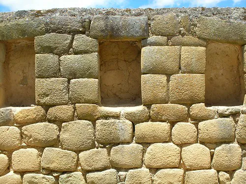
Recognized as the most extensive archaeological complex in Ecuador, the Ingapirca Ruins present a precise record of pre-Columbian expansion. The site is defined by the Temple of the Sun, an elliptical structure demonstrating advanced Inca stone-masonry techniques overlaid directly onto established Cañari foundations. The mortarless, perfectly fitted andesite blocks align precisely with the solstices, indicating the complex served dual religious and astronomical functions. Visitors examine the structural remnants of elite residential quarters, ceremonial baths, and administrative plazas that facilitated imperial control over the region. To understand the intricacies of the overlapping cultures, many visitors secure a private tour with a specialized guide, ensuring accurate interpretation of the stonework and historical timelines.
The physical setting of the ruins amplifies their historical gravity, situated at an elevation of 3,160 meters within the Cañar province. The surrounding high-altitude landscape is characterized by steep, terraced valleys that the Inca utilized for agricultural output and rapid communication along the Qhapaq Ñan road system. Analyzing the specific landmarks within the complex requires a minimum of two hours on-site, allowing sufficient time to walk the perimeter of the primary fortification and observe the intricate aqueduct channels. Connecting this site with other regional highlights creates a highly efficient use of an open itinerary day, solidly anchoring the southern Ecuadorian travel circuit.
Cajas National Park
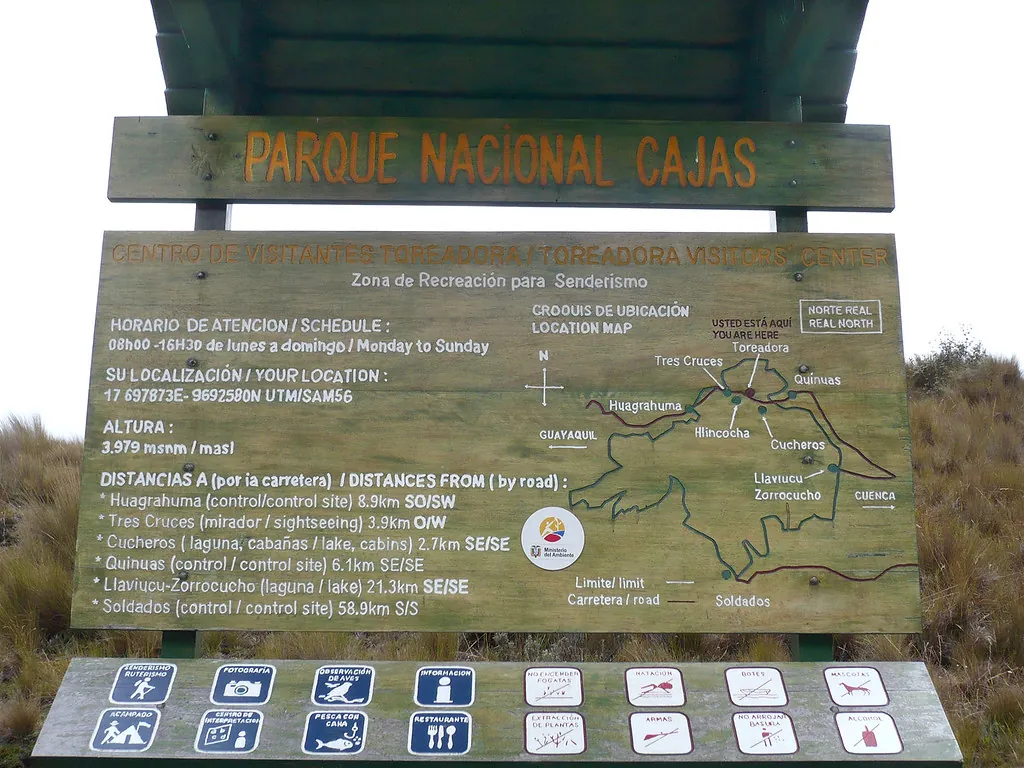
Positioned 30 kilometers west of Cuenca, Cajas National Park encompasses a rugged, 285-square-kilometer expanse of high-altitude páramo ecosystem. The topography is defined by over 200 interconnected glacial lakes, which supply the majority of the region’s drinking water and feed rivers flowing toward both the Pacific Ocean and the Amazon Basin. The park stands in sharp contrast to the structured archaeological sites of the region, focusing entirely on raw geological formations and endemic biodiversity. Hikers navigate a network of challenging trails that weave through dense, high-altitude grasslands and distinctive patches of paper-bark Polylepis trees, recognized as some of the highest-growing forests on the planet.
The extreme elevation of the park, ranging from 3,100 to 4,450 meters, produces volatile weather patterns that demand strict preparation. Temperatures drop rapidly, and heavy fog frequently reduces visibility within minutes, requiring visitors to carry appropriate layered clothing and reliable navigation tools. Those who acclimatize successfully are rewarded with sightings of wild alpacas, spectacled bears, and the Andean condor. Before attempting the higher trails, travelers should review our altitude sickness prevention guide to mitigate the physical risks associated with rapid ascents. The stark, isolated environment provides an essential ecological counterpoint to the cultural excursions in the surrounding valleys.
Gualaceo & Chordeleg
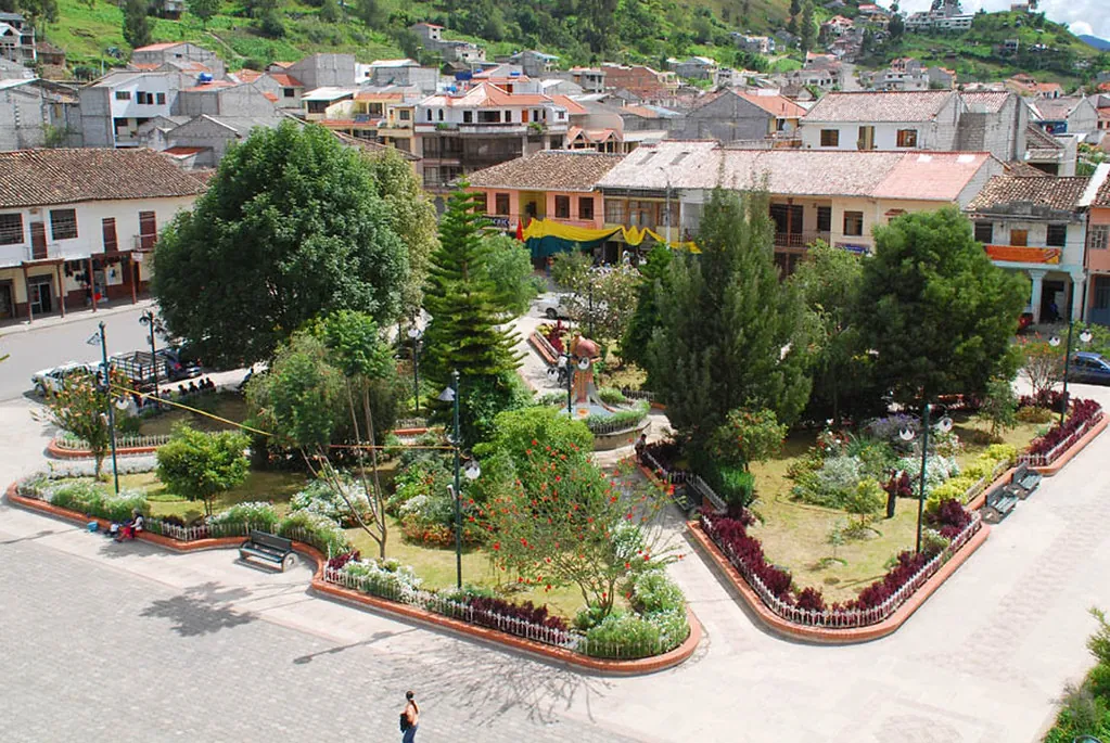
Traveling east from Cuenca into the Santa Bárbara river valley introduces visitors to Gualaceo, an agricultural and artisanal center crucial to the Azuay province’s economy. The town operates as the primary hub for traditional textile production, specifically the creation of macana shawls utilizing the complex ikat dyeing method. Local weavers utilize backstrap looms to produce intricate geometric patterns, a pre-Columbian technique maintained by a small number of specialized families. The central market of Gualaceo also functions as a critical point for regional agriculture, distributing high-altitude produce and offering visitors a direct look at the local food supply chains documented in our Andean cuisine guide.
Situated ten minutes further up the valley, the municipality of Chordeleg specializes almost entirely in metallurgy, specifically fine silver and gold filigree. The central plaza is surrounded by dozens of specialized workshops where jewelers manipulate microscopic metal threads into elaborate earrings, bracelets, and ornamental figures. Because the two towns sit in such close proximity, they are highly optimized for a combined afternoon itinerary following a morning archaeological visit. Travelers routinely maximize their schedule by joining a full-day cultural tour linking Ingapirca with the artisan villages, completely removing the logistical friction of coordinating multiple rural bus transfers.
“The route descending into Gualaceo provides clear visibility of the agricultural terracing. Ensure you sample the slow-roasted hornado at the central market, which remains the staple protein of the local economy.”
– Regional Agricultural Specialist
Crafting Your 24-Hour Excursion
Executing a comprehensive single-day circuit through the southern Andes requires precise logistical sequencing, particularly when integrating archaeological sites with rural artisanal centers. The most effective routing initiates with a 7:00 AM departure from the Terminal Terrestre in Cuenca, directing travelers north into the Cañar province. Arriving at the main complex before 9:30 AM guarantees cooler temperatures and avoids the heavy afternoon cloud cover typical of the high Andes. Following a two-hour structural analysis of the site, vehicles can loop southeast toward the Santa Bárbara valley, positioning visitors in Gualaceo for a late afternoon meal and textile observation before the return drive to Cuenca.
“Optimizing your time in the Azuay and Cañar provinces requires early morning departures. Combining the precise stonework of Ingapirca with the textile workshops of Gualaceo creates the most comprehensive 24-hour itinerary available.”
Independent drivers gain maximum flexibility along this route, allowing for unprompted stops at panoramic valley overlooks. However, the mountainous terrain is subject to frequent landslides during the rainy season, making it mandatory to consult the Ministry of Infrastructure and Transport for real-time highway condition reports before departure. For those utilizing the interprovincial bus network, direct routes connect all major hubs, though transfer times at rural junctions can add up to two hours to the total transit duration. Regardless of the chosen transportation method, reviewing our complete logistical guide to reaching the ruins ensures a highly structured and predictable excursion.
Travel Health: Managing Altitude on Cuenca Day Trips
Cuenca itself sits at roughly 2,560 meters (8,400 feet) above sea level—a moderate altitude where most visitors feel only mild effects after arrival. The real risk emerges when day trips push significantly higher. Ingapirca climbs to 3,160–3,200 meters, and Cajas National Park ranges from 3,100 to 4,450 meters. That additional 600 to 1,900 meters of elevation gain, often reached within a two-hour drive, can trigger acute mountain sickness in travelers who skipped acclimatization.
Altitude Sickness by Destination
| Destination | Elevation | Risk Level | Common Symptoms |
|---|---|---|---|
| Cuenca (baseline) | 2,560 m / 8,400 ft | Low | Mild fatigue, slight headache on arrival |
| Ingapirca Ruins | 3,160–3,200 m / 10,367–10,500 ft | Moderate | Headache, shortness of breath on stairs, nausea |
| Cajas National Park (lower trails) | 3,100–3,800 m | Moderate–High | Headache, dizziness, reduced appetite |
| Cajas National Park (upper trails) | 3,800–4,450 m / 14,600 ft | High | Severe headache, vomiting, ataxia, confusion |
Practical Prevention Protocol
- Acclimatize in Cuenca first. Spend at least 24–48 hours in the city before scheduling any high-altitude excursion. Your body begins producing extra red blood cells within hours, but meaningful adaptation takes a full day or two.
- Hydrate aggressively. High-altitude air is exceptionally dry. Drink 3–4 liters of water daily starting the day before your trip. Avoid alcohol the evening prior—it compounds dehydration and masks early symptoms.
- Ascend gradually when possible. If driving to Cajas, stop briefly at the lower ranger station (3,100 m) before continuing to the Toreadora Lake area (3,900 m). Even 20 minutes of rest at an intermediate elevation helps.
- Know the warning signs. A mild headache at Ingapirca is common and manageable. Persistent vomiting, loss of coordination, or confusion at Cajas means descend immediately—do not wait. Severe acute mountain sickness can become life-threatening above 4,000 meters.
- Consider acetazolamide (Diamox). Travelers with a history of altitude sensitivity should consult a physician before the trip. A standard 125 mg dose taken twice daily, starting 24 hours before ascent, significantly reduces symptom severity.
- Coca leaf tea is available locally. Many hotels in Cuenca offer mate de coca at breakfast. While not a substitute for proper acclimatization, it provides mild relief for some travelers and is legally sold throughout Ecuador.
Gualaceo and Chordeleg sit roughly 200 meters below Cuenca in the Santa Bárbara valley, making them the safest choices for travelers still adjusting to altitude. If you experience persistent symptoms after 48 hours in Cuenca, prioritize these lower-elevation destinations and save Ingapirca and Cajas for later in your itinerary. For a complete breakdown of symptoms, treatment, and emergency protocols, consult our altitude sickness prevention guide.