Entering the Complex: The Cañari Foundations
The physical journey through Ecuador’s most prominent archaeological site begins precisely where the ancient history of the region took root. Pilaloma represents the oldest sector of the Ingapirca Ruins complex, serving as the critical anchor point for understanding the original pre-Inca inhabitants. Long before the imperial expansion of the Inca Empire reached these southern highlands, the Cañari people established a sophisticated administrative and religious center here. By initiating the visual and historical progression at Pilaloma, visitors immediately grasp the foundational layer of this dual-heritage site before encountering the imposing imperial additions that dominate the upper terraces.
Unlike the strict linear and rectangular geometries usually favored by later conquerors, the Cañari architects based their sacred designs on the natural curvature of the celestial bodies they worshipped. The Pilaloma sector features a distinct semi-elliptical wall and circular tomb. Historical and archaeological consensus indicates that the Cañari specifically constructed these rounded gathering areas to venerate the moon, their primary deity. The lunar focus governed their agricultural cycles, reproductive planning, and religious calendar. Observing these early foundations offers a stark contrast to the standard rectangular, sharp-angled designs implemented by the Inca, although the conquerors famously adapted their own solar-focused Temple of the Sun into a rare elliptical shape here. Visitors who want to fully comprehend these overlapping architectural narratives often join a small-group archaeological tour to benefit from the direct interpretation of specialized guides.
As of 2026, the ruins are co-administered by the indigenous Cañari community and the Instituto Nacional de Patrimonio Cultural (INPC). This collaborative management ensures that native Kichwa-speaking guides remain at the forefront of the site’s preservation and narrative. Their presence guarantees that the oral histories and traditional understandings of the Cañari lunar sites are communicated accurately to international visitors, maintaining the cultural integrity of the complex.
The Quiyujaca Mortar Technique
The most visible identifier of original Cañari construction lies in the binding materials. Throughout the Pilaloma sector, the ancient walls are held together by a highly durable, localized cement known as quiyujaca. This pre-Columbian mortar is a precise mixture of yellow mud and clay used to bind rounded river stones gathered from the surrounding valleys. The quiyujaca technique allowed the Cañari to build robust, curving walls that could withstand the harsh, wet conditions of the high Andes. The yellow tint of the mud remains distinctly visible today, providing a visual chronological marker for archaeologists mapping the earliest phases of the settlement.
Inca Dry Ashlar Masonry
In direct contrast to the mud-bound walls of the Cañari, the Inca expansions utilize classic dry ashlar masonry. The imperial blocks crowning the upper sectors are uniquely carved from green diorite and andesite volcanic stones. These stones were extracted, transported, and shaped without the use of iron tools or mortar. The Inca stonemasons finished the outward-facing sides of these blocks with a specific “pillowed” or convex technique. This engineering choice was highly deliberate; the convex shapes shed heavy rainwater efficiently and provide critical interlocking flexibility to resist the intense seismic activity typical of the Andean fault lines.
The Royal Burials of Pilaloma
The circular plaza of Pilaloma is not merely a structural foundation; it is a sacred necropolis. Archaeological excavations conducted within the center of this lunar-aligned sector unearthed one of the most significant discoveries in the region: an elite Cañari priestess tomb. The positioning of her grave at the exact center of the oldest gathering space emphasizes her supreme role in the religious hierarchy of the ancient society. The careful exhumation of the site provided vital data regarding the rigid social stratification and complex ritual practices that governed the Cañari people prior to the Inca conquest.
The scale of the burial site illustrates the power held by the elite class. The tomb contained a total of 11 skeletons. The high priestess was buried alongside 10 of her servants, whose remains were arranged systematically around her central position. Bioarchaeological analysis suggests these individuals were sacrificed to serve as eternal companions and protectors in the afterlife, a practice reserved only for the highest echelons of Andean nobility. For those interested in the broader historical context of these burial rituals, reading our comprehensive overview of Ancient Origins & Architecture provides deeper insight into the societal structures that demanded such sacrifices.
Perhaps the most compelling artifacts recovered from the Pilaloma tomb were the offerings placed with the deceased. The burial contained thousands of sacred spondylus shells. These rare, thorny marine oysters are entirely foreign to the high-altitude Andes; they thrive only in the warm, coastal waters of the Pacific Ocean. In pre-Columbian times, spondylus was considered more valuable than gold, serving as a primary currency and a vital offering to the gods of water and fertility. The presence of such a massive quantity of spondylus in a high-mountain grave demonstrates the existence of extensive, highly organized trade routes connecting the Ecuadorian coast to the Andean highlands. Travelers who wish to explore these ancient routes comprehensively often book a private excursion with dedicated guides, which allows for a tailored pace through the complex and the surrounding historical landscape.
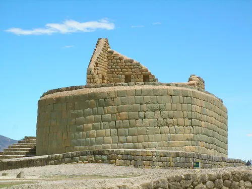
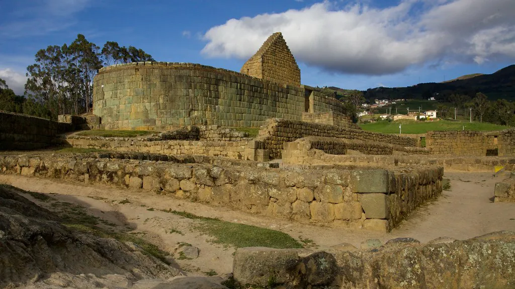
The Temple of the Sun (El Castillo)
Dominating the entire archaeological complex is the Temple of the Sun, locally referred to as El Castillo. This structure is an architectural anomaly within the Inca Empire. While standard Inca temples are rectangular, this temple features a perfect elliptical design, a direct compromise and fusion between the circular preferences of the conquered Cañari and the solar devotion of the conquering Inca. The dimensions of the temple are staggering given the high-altitude terrain. The elliptical base measures exactly 37.10 meters in length and 12.36 meters in width, with its structural retaining walls reaching up to 4.10 meters in height. It stands as a masterclass in ancient engineering, constructed entirely of finely fitted green diorite blocks.
The true genius of the Temple of the Sun lies in its astronomical precision. The structure was not merely a place of worship; it was a highly functional solar observatory. The central upper chamber is aligned perfectly to capture the sunlight during the solstices. During the winter solstice on June 20-21, a single, precise beam of sunlight penetrates the exact center of the upper chamber’s doorway, illuminating the inner sanctum. This event, celebrated annually as the Inti Raymi festival, marked the beginning of the new agricultural year and reaffirmed the divine power of the Inca emperor as the son of the sun. In 2026, the Inti Raymi alignments continue to draw researchers and visitors from around the globe. If you are scheduling a trip to witness this phenomenon, consulting our guide on Planning Your Visit will ensure you secure the necessary admission tickets well in advance.
The Lunar Calendar Stone and the Ingachungana
Beyond the imposing walls of the main temple, the complex is scattered with specialized utility stones that highlight the daily lives and scientific achievements of its inhabitants. One of the most critical artifacts is the Lunar Calendar Stone. This large, flat Cañari bedrock carving features 28 precise circular cavities. Native astronomers would fill these carved holes with rainwater. On clear nights, the still water acted as a mirror, reflecting the stars and the moon. By tracking the lunar reflections across the 28 cavities, the priests mapped the 28-day lunar cycle. This precise tracking was essential for dictating agricultural planting, harvesting schedules, and reproductive cycles within the community.
Located just north of the main temple is another carved rock formation known as the Ingachungana, which translates from Kichwa to the “Inca’s Game.” Despite its playful name, the archaeological evidence points to a strictly ceremonial function. The rock features an array of precise gullies, interconnected channels, and carved seats decorated with relief sculptures of coiled snakes. The snake was a sacred symbol of the underworld (Uku Pacha) in Andean cosmology. Historians conclude that the Ingachungana was historically utilized for ritual ablutions and the ceremonial pouring of fermented chicha (corn beer), which would flow through the channels as an offering to the earth. To learn more about the enduring legacy of this traditional beverage, read our guide to Traditional Andean Cuisine.
The Akllahuasi and the Qhapaq Ñan
Adjacent to the Sun Temple lie the excavated foundations of five distinct, interconnected rooms. These structures comprise the Akllahuasi, or the House of the Chosen Women. The inhabitants of this sector were the “Sun Virgins”—young women selected from across the empire for their specific skills and physical perfection. The women living in the Akllahuasi lived in strict seclusion. Their primary duties involved weaving the highly intricate ceremonial textiles worn by the priests and the emperor, as well as brewing the vast quantities of chicha required for religious festivals and political diplomacy at the site.
The prestige of the structures immediately surrounding the main temple is denoted by a specific architectural hallmark: double-jamb trapezoidal doorways and double-framed niches. In the visual language of Inca architecture, the double jamb signifies high political and religious prestige. It acts as a physical barrier, restricting access to the most sacred ceremonial precincts and indicating that only the highest-ranking nobility or priesthood could enter the inner sanctum.
Connecting all of these structures—and ultimately connecting the site to the rest of the continent—are the main stone pathways traversing the complex. These specific roads are officially recognized segments of the Qhapaq Ñan, the Great Inca Road system. This monumental engineering feat historically linked the site directly to the imperial capital of Cusco in modern-day Peru, and the northern administrative outpost of Quito. Independent travelers looking to expand their understanding of the region’s connected history often utilize a comprehensive regional itinerary that explores surrounding towns and the ancient trade routes detailed in our guide to Exploring Ecuador’s Nearby Attractions.
Practical Logistics for the 2026 Season
Accessing the specific landmarks within the complex requires careful logistical planning, particularly for independent travelers navigating the highlands. The Ingapirca Tourism Information Portal notes that the site experiences highly localized microclimates that differ drastically from nearby urban centers. While the morning sun can be intense, visitors should anticipate sudden temperature shifts. Averages range sharply from 8°C to 15°C (46°F to 59°F), and frequent, low-intensity afternoon rain showers roll over the complex, particularly between the months of December and May. Proper layering and rain protection are strictly necessary to safely explore the exposed Temple of the Sun and the wider Qhapaq Ñan trails without interruption.
Furthermore, navigating the terrain at this altitude requires physical preparation. To ensure a safe visit, review our detailed protocol on How to Avoid Altitude Sickness in the Andes before attempting the steep staircases surrounding the main temple.
Traveler Transit Tip: For independent travelers heading to the site in 2026, the most reliable and economical public transport is the Cooperativa Cañar bus line. They operate direct routes from Wednesday to Sunday departing from Cuenca’s Terminal Terrestre located on Av. España. One-way ticket prices currently average $4.00 USD, making it a highly accessible journey for those comfortable navigating local transit schedules. Ensure you check the return times immediately upon arrival at the ruins, as late-afternoon buses back to the city are limited.
— Regional Transit Authority Updates, Azuay Province
Whether analyzing the precise geometry of the green diorite stones, understanding the agricultural necessity of the lunar calendar, or observing the strict architectural hierarchy of the Akllahuasi, navigating the landmarks of this complex offers an unparalleled view into pre-Columbian life. By understanding the function of each structure, visitors transition from merely looking at ancient ruins to reading the historical blueprint of two brilliant, colliding civilizations. For deeper logistical details on schedules, bus routes, and parking, please refer to our comprehensive guide on How to Get to Ingapirca Ruins, and ensure you review the Visitor Rules & Guidelines to help preserve these fragile structures for future generations.